What are Mapsted Indoor Maps?
Mapsted indoor maps are maps of your indoor space. Indoor mapping is the process of converting your floor plans that you send to us into digital, interactive representations of indoor spaces. With Mapsted’s indoor mapping platform, any company can be enhanced to display data in the context of an indoor map.
How do these indoor maps work?
Once you send in your static map ( any file form is fine, as long as it is to scale), Mapsted will convert them into intelligent, 3-D digital maps by overlaying multiple data layers to create scalable, location-aware applications. Indoor maps are essential to the creation of a fully functional indoor navigation platform.

Mapsted’s indoor maps provide seamless outdoor-indoor navigation and localization with turn-by-turn blue dot navigation without the use of beacons or other external hardware.
Learn more
Edit and manage your map and properties with Manage CMS. A software dedicated to helping you manage and exceed your business goals.
Learn more
Create and send contextual messaging, events, sales, and notifications. Plan for future campaigns to increase revenue while keeping costs low.
Learn more
Visualize real-time location data through foot fall heat maps, user trajectories, visit time, number of visitors, and more. Back your decision making with compelling visual stories that best represent your data.
Learn moreYou can use these maps as a separate SDK however, users will literally just see the map. They will not have the blue-dot turn-by-turn navigation feature. Indoor maps provides the context users need to use indoor wayfinding, therefore it is highly recommended that Mapsted’s indoor maps is paired with our indoor wayfinding SDK. Even though they are fully functional independent SDK’s, when paired together they unlock a world of endless possibilities.
The maps you send us are integrated with various platforms and data sets via SDK’s which allow for a wide range of map-enabled uses. Our in house team are experts when it comes to complex indoor maps. We know that map digitalization is often more than converting files. Spatial information needs to be understood, and customized. Mapsted helps you establish a strong foundation that gets you where your maps need to go.
Mapsted’s Indoor Mapping Technology
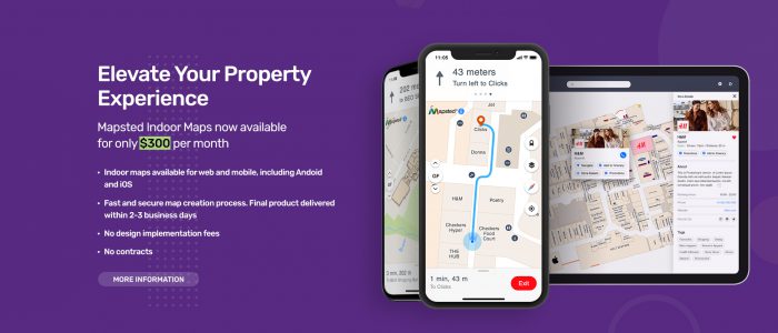
Mapsted Maps offers customers a searchable, interactive map that helps them plan and visualize their routes. The seamless indoor-outdoor wayfinding experience offered by this product helps visitors easily navigate inside a complex venue, and also allows for easy navigation across platforms. That means customers can search out points of interest on a kiosk or website, and navigate to them in real time using an app on their smartphone.
Mapsted Maps has two available products: Maps basic and Maps Premium.
- Mapsted Maps – Web
Searchable interactive map & wayfinding
Mapsted Maps Web offers visitors and staff a searchable, interactive map that helps them plan and visualize their routes.
- Use the directory to discover and explore points of interest
- Look for specific destinations by keyword or category using intelligent search
- Easily plan a route to navigate between points of interest on the property
- Mapsted Maps – Mobile
Indoor Positioning & turn-by-turn Blue Dot navigation
Mapsted Maps Mobile with indoor positioning allows for seamless outdoor-indoor navigation and localization without the use of beacons or other external hardware.
- Use multi-destination and accessibility routing to customize your route planning
- Avoid confusing directions with map auto-orientation
- Enable location sharing to easily meet up with friends and family
Key Mapsted Map Features
Suggested Read: Characteristics of an ideal university with an IPS
Interactive Map: Map interactions are a fundamental component of Mapsted’s cross-platform SDK for Mobile, Web and Kiosk. The map view supports multiple interactions, map gestures, map clicks, and QR code scanning. Map gestures allow for pan, zoom, tilt, and rotations, while map clicks allow for customizable actions (e.g., selection of entities).
Map click events indicate when the user has clicked on the map. A map click event consists of a click type, a click location, and a click entity. A single click on a location will select that entity whereas a double click will zoom into the map.
QR Code scanning allows a user to quickly scan the provided QR code to access a mobile version of the map.
Offline maps: All downloaded map data is automatically stored in a local database and available for use offline. The SDK will automatically download map data, as needed, based on what is nearby. Map data downloads can also be managed programmatically, triggered by UI interactions.
Custom map viewYou can power your map using our position location technology, while using your own map. Mapsted uses Open Street Maps as the geofence for user locations, buildings, and other map elements. If your system uses a basemap such as Google maps or Apple maps, please contact us, so we can make sure that our user locations, buildings, and other map elements are appropriately georeferenced for your basemap.


